How are Rivers formed
Rivers are natural flowing water course usually fresh water flowing towards an ocean, sea, lake or another river. At some places a river flows into the ground and becomes dry at the end of its course without reaching at another water body.

Rivers are part of the hydrological cycle. Water generally collects in a river from precipitation through a drainage basin and other sources such as groundwater spring and the release of stored water in natural ice and snow packs. example from glaciers.
I. Rivers are formed through a process called fluvial erosion. River erosion is the wearing away of rock, soil and sediment by the movement of water. This can happen in many ways.
II. One way rivers are formed is through the gradual erosion of land by rain and melting snow. As water flows over land, it picks up sediment and carries it downstream. Over time, this process can create a channel or stream bed that becomes a river.
III. Another way rivers are formed is by the melting of glaciers. As glaciers melt, they release large amounts of water, which can carve deep channels across the landscape. These channels can then become rivers.
IV. Rivers can also form as a result of tectonic activity. When tectonic plates move and collide, they can create mountain ranges and other features that affect the flow of water. As water flows downstream, it can form channels and form rivers.
V. Once a river is formed, it continues to shape the landscape through erosion, sediment transport, and deposition. Over time, rivers can create gorges, gorges, and other features that are both beautiful and geologically significant.
A river or a stream is a body of flowing water. The place from where a river originates is called its source. The end point of the river where meets a large body of water such as a sea or an ocean is known as its mouth. The course of river can be divided into three stages:
(a) The upper course
(b) The middle course
(c) The lower course
The shape of the river valley changes as the river flows through these three courses .The speed of the flow of the river also changes as an agent of gradation.
The upper course
In this region, a river usually flows through mountainous regions. The volume of water is not much. But the gradient being steep, the water flows swiftly, and its eroding and transporting power are at the maximum.
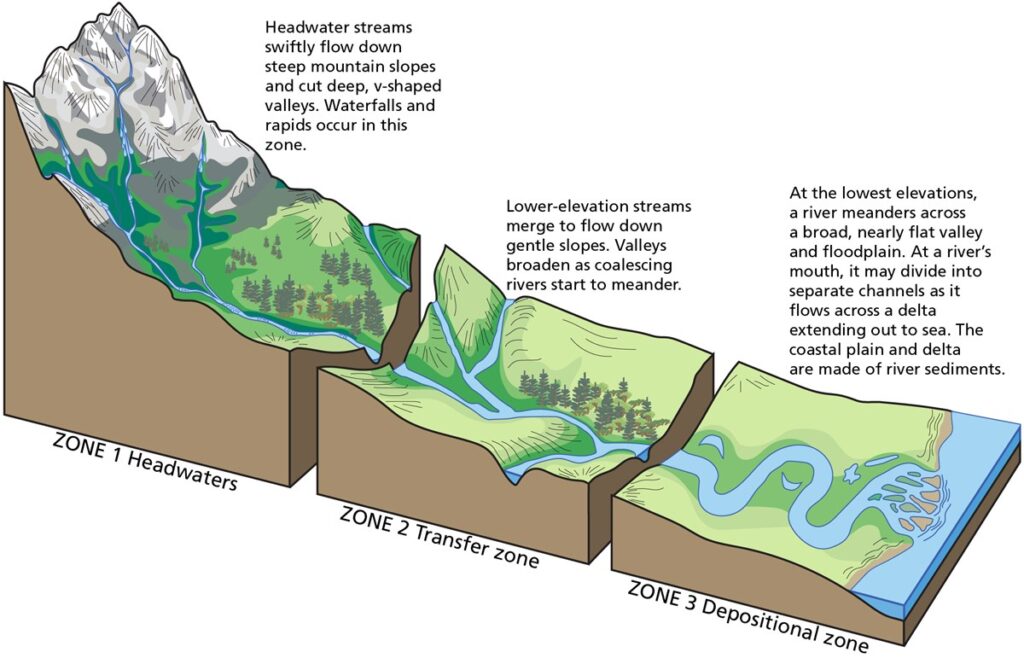
In its upper reaches, a river may wind between a series of Hills. Valleys formed by the river are narrow and steep sided. Water is often slowed by the Rough river bed, though there maybe fast flowing rapids and waterfalls.
The river in this course develops typical land forms:
1. Gorge or I- shaped valley:
When a river flows through a mountainous region made up of hard rock with little rainfall, most of the energy of the river is spent in down-cutting action, resulting in a narrow valley with almost vertical walls. The Indus river and many tributaries of the Ganga flow through many deep gorges.
A gorge of a magnified size is known as a canyon. For example, grand canyon of river Colorado in U.S.A.
2. V-shaped valley:

When a river flows through a mountainous region made up of relatively soft rock with plenty of rainfall, the sides or the banks of the river are easily eroded and widened by increase in volume of the river water from time to time, resulting in a V-shaped valley.
3. Waterfall:
A waterfall is a steep descent of a river over a rocky ledge .When the river waterfalls down almost vertically from a sufficient height along the course of the river, it forms a waterfall.
When a river flows from hard rock to soft rock, the softer rock is easily eroded forming a ledge over which the river falls. As the waterfalls over the ledge, it creates a depression known as a plunge pool.
The middle course
In the middle course, the river enters the plain. As the gradient decreases, the flow of the river slows down and so does its energy. The volume of water increases considerably. As the slope flattens, the river cuts less into its riverbed. Instead its widen its banks and its riverbed, giving rise to U-shape valley. The river’s flow is less turbulent as the land becomes less steep at its middle level. Tributaries join it, increasing its level of water and allowing it to run easily over shallower ground.The main work of the river is to transport sediment. The river in the middle course develops some typical land forms:
1. Flood plain:
A flood plain is the low flat area of land on either side of a river. It can be found in the middle course .
2. Meanders :
As the gradient is almost flat the river’s movement becomes, and it develops S-shaped meanders. where such meanders occur, the river can be described as a meandering river. “Meander” means too wander.
3. Ox-bow lake :
An ox bow lake is produced when a meander forms almost a complete circle with a narrow neck. Sometime this narrow neck is cut by the river as it flow straight.The water follows the shorter rout leaving the broader meander loop abandoned.This meander loop filled with water converted into lake is known as Ox-bow lake.
4. Braided river:
When a river carries an enormous amount of load, it is unable to carry it, all the way to its mouth.

This causes the river to divide into many networks of channels forming island in the river channel. Such a river is known as a braided river. The river is very useful in this stage. It is used for navigation and transportation. It supplies water for irrigation.
The lower course
In this stage the river flows considerably slow. This is because the gradient almost flat. The river also flows sluggishly due to the heavy load it is carrying. The main work of the river here is that of deposition. By the time it reaches its lower levels, the river has widened enormously. The steeper valleys of upper and middle section give way to wider flood-plains, often finishing in an estuary or delta. The river in this course develops typical land forms.
1. Delta (△) :
A delta is a triangular piece of land that develops at the mouth of a river by the deposition of sediment. This name was first used to describe the delta of the Nile. The river has less energy to cut into the land. it can no longer carry the heavy load of sea, a new land is formed known as delta. The Ganga- Brahmaputra delta is one of the largest deltas of the world.
2. Distributary:
When sediments built along the river’s main channel, the channel get blocked and the river is forced to divide into branches called distributaries.
3. Estuary :
Many rivers do not form delta especially along rocky coast. Instead they have a narrow, gradually widening bay at the mountain cutting deep island. Such a funnel-shaped opening at the mouth of a river is known as an estuary.
Features of rivers:
Rivers are natural water streams that flow from higher elevations to lower elevations, usually toward an ocean, sea, or some other body of water. They play an important role in shaping the Earth’s landscape and have many distinctive features. Here are some key features of rivers:
1. Source:
The source or origin of a river is the point from where it begins. It can also be a spring, glacier, lake or confluence of small streams.
2. Tributaries:
Tributaries are small rivers or streams that flow into a larger river. They contribute water and sediment to the main river and help increase its volume.
3. Channel:
Channel refers to the path or course through which a river flows. This is the area where water is confined and can vary in width, depth and shape.
4. River banks:
River banks are the sides or banks of a river. They are generally formed by river erosion and depositional processes and can vary from gentle slopes to steep cliffs.
5. Riverbed:
Riverbed is the bed of the river where the water flows. It consists of sediments, such as rocks, sand and silt, that can be continually shaped by river flow.
6. Visarps:
Visarps are curves or bends in the course of a river. They are formed by the erosive action of water, which gradually wears away the outer edge and deposits sediment on the inner edge of the curves.
7. Flood plain:
A flood plain is a flat or gently sloping area adjacent to a river. It is formed by sediment deposition during floods and is an essential part of the riverine ecosystem.
8. Rapids and Waterfalls:
Rapids are areas of fast-flowing and turbulent water in a river, usually caused by the presence of rocks or other obstacles. A waterfall occurs when a river drops suddenly in height, forming a vertical or near-vertical descent of water.
9. Estuary:
An estuary is a partially enclosed coastal body of water where a river meets a sea or ocean. It is characterized by a mixture of freshwater and salt water and is often a highly productive and diverse ecosystem.
10. Delta:
A delta is a landform formed at the mouth of a river where it flows with less velocity into a body of water, such as a lake, sea, or ocean. Deltas are usually triangular or fan-shaped and are formed by the deposition of sediment brought by the river.
11. Rivers and streams
Rivers and streams are often considered major features within a landscape, however they actually only around 0.1 % of the land on earth. They are made more obvious and significant to humans by the fact that many human cities and civilization are built around the fresh water supplied by rivers and streams. Most of the cities of the world are situated on the bank of rivers as those used to as source of water.
12. Subsurface stream
Most of rivers flow on the surface. Subterranean rivers flow underground in caves. Such rivers are frequently found in regions with limestone geologic formations. Subglacial streams are the braided rivers too that flow at the beds of glaciers and ice sheets because of the gradient in pressure due to the overlying weight of the glacier such streams can even flow uphills.
13. Permanence of flow
An intermittent river only flow occasionally and can be dry for several years at a time. These rivers are found in regions with limited or highly variables rainfall because of geological conditions such as a highly permeable riverbed.
14. Uses of rivers
Rivers have been a source of food since prehistory. They are often a rich source of fish and other edible aquatic life and are source of freshwater. Which can be used for drinking and irrigation. Rivers also provide an easy means of disposing of waste water.
15. Navigation

Rivers have been used for navigation for thousands of years. The earliest evidence of navigation is found in the Indus valley civilization. Which existed in North Western India around 3300 BC. these navigation provides a cheap means of transport and is still used extensively on major rivers of the world. Like the Amazon, the Ganges, the Nile, the Mississippi and the Indus. Indian rivers like the Ganga, the Brahmaputra, the Krishna, the Kaveri, the Yamuna and the Mahanadi.
16. Source of energy
Fast flowing rivers and waterfalls are widely used as source of energy via water mills and hydroelectric plants. The coarse sediment, gravel and sand generated and moved by rivers are extensively used in construction. Rivers are often managed and controlled to make them more useful or less disruptive to human activity.
-» dams may be built to control the flow, store water or extract energy.
-» Canals connect rivers to one another for water transfer or navigation.
These are some of the salient features of rivers. They vary greatly in size, shape and characteristics, which are influenced by factors such as climate, geology and human activities in their respective watersheds.
Quick links:
- Parliamentary government 50 MCQs and Explanations
- What is weathering Its Process, types and factors
- Importance of Rivers: Nurturing Life and Sustaining Ecosystems
- Deforestation: it’s definition, causes, effects and solutions
- MCQs on Indian Constitution with Answers free PDF
- Critical perspective of the construct of Intelligence 50 MCQs
Read also :
Social sharing ⬇️


